|
|
Tigger Travels - Family Adventure Journal
Photos From Tigger`s Travels and MORE!
The Gaillard (Culebra) Cut, Panama Canal! Part 4
Back
|
|
Panama Cruise January 2011 - Last Trans-canal trip planned for the Disney Wonder at this time. |
Once past Gatun Lake, the shores will close in and you will be in the Chagres river. This river serves as the largest tributary into the lake and canal. It's use as part of the canal was planned as far back as 1876 when France started the first attempt at the canal under the management of Count Ferdinand de Lesseps, a french business man.
The last large island on the right gives away to one last water passage, and as soon as there are no more passages to the right, you have arrived. This area is as little as a few hundred feet wide, but it is to be wider with the opening of the new canal locks. On the north east side there is a rail road track that was built between 1850 and 1855. It is supposed that at one time, with the discovery of gold in California in 1848, that rail was carrying more cargo that on today's ships.

Click to enlarge image
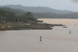
Here you can see some of the continuing work on the Panama Canal and the markers of the left side of the canal circling around in the distance. Also in the distance you can see the next two markers for canal navigation. |
|
This rail follows the edge of the Chagres river then crosses it as the canal takes off into the Culebra cut leading to the Continental Divide. On the Disney Wonder, we were honored by several presentations from Captain Kenneth Puckett (retired). He was a Senior Pilot and Panama Canal Port Captain and still serves as the Historian for the canal. One of his stories told how he was piloting a steam vessel through the canal many years ago when he lost all power near the Chagres railroad bridge. As pilot he helped stop the ship from hitting (and probably destroying that bridge) with inches to spare. He said that someone below deck indicated they could have reached out and touched the bridge at the closest point.
In the river we did spot a large alligator swimming along the shoreline. Within a mile we spotted a second one. Only it's head was visible but it looked like a smaller critter.
As you enter the Culebra Cut the shoreline becomes straighter. There are fewer tributaries and you begin to see many more hills cut with stair steps to prevent erosion. As we passed there were crews spraying grass and seed on one hill to sure up the ground in a newly cleared slide from the previous month.
Occasionally, you will find piles and pieces of what look likes large white PVC pipe. This is used in the drilling and blasting of the hillsides to maintain the integrity of the banks. The closer you come to the continental divide, the higher the hills and the need for blasting becomes very apparent.
Just at the continental divide is the beautiful Freedom bridge. It is a suspended bridge that hangs from two large pylons in the middle of each end of the bridge. Unlike the San Francisco bridge, the cables are all in one line along the center of the whole bridge. It sits about 255 feet above the surface of the water, a height that can be felt as you go under.
The day we crossed, the freedom bridge was unusable because the east access of the bridge was completely washed away. Crews were working to bring in more gravel and cement to rebuild the ground and allow the bridges use. Passing under the bridge, looking up and back provides an architectural photo opportunity that really accents the beauty of the lines and supports on the bridge. The sun is shining, even highlighting the attractive structure.
The cut through the continental divide is nothing short of amazing. They digging was started with some of the equipment the French brought in the area in the 1870s. Eventually American steam locomotives were used to finish the dig which involved union labor and a whole new set of challenges. During the digging, six million pounds of dynamite were used. In the tropical environment, this was very dangerous and the dynamite was easily found unstable and dangerous. Many lives were lost here and throughout the construction project, 5,608 under the American construction that finished the canal in 1914.
The whole mountain center was removed in ever widening stair steps that extend to the top. The face of each step is dotted with a grid of anchor bolts that extend deep into the mountain and hold the mountainside in place. Cement and steel re-bar were used by the ton to create this face.
Through this section of the canal we passed the headquarters of the dredging operations for the canal. Due to the size of the whole Panama Canal, there is always dredging of some kind taking place. As we passed, there were dozens of tanks welded together with three ibeams. These serve as floats for the pipe that carries away the dredged material. At some point in the canal you will likely see these in use. There are also a number of drilling and dredging barges and in the area there are many earth carrying barges that transport waste to the far side of the lake and dumped out the bottom.
This cut through the continental divide really punctuates the accomplishment of more than 45,000 workers from the United States, Europe and the West Indies. In 1996, it was named the 7th wonder of the world.
2011 Disney Wonder Panama Canal Cruise Index |
Back
|
Daily Navigator/Iwa Published Schedule
|
|

